卡普喬魯瓦區
卡普喬魯瓦區是非洲中部國家烏干達的一個區,由東部區負責管轄,首府是卡普喬魯瓦,海拔高度1,800米,距離姆巴萊約65公里,主要的經濟產業有自給農業和畜牧業。2014年普查人口為104,580。[1]
| 卡普喬魯瓦區 | |
|---|---|
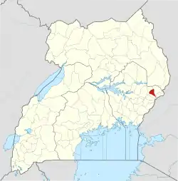 2010年以後的卡普喬魯瓦區範圍以紅色標示 | |
| 坐标:1°20′N 34°34′E | |
| 國家 | |
| 地理區 | 東部區 |
| 首府 | 卡普喬魯瓦 |
| 海拔 | 1,800 公尺(5,900 英尺) |
| 人口(2014年普查) | |
| • 總計 | 104,580人 |
| 时区 | 東非時間(UTC+3) |
| 網站 | www |
2005年,布克瓦區自本區析出。2010年,奎恩區自本區析出。

2005年以前的行政區劃
參考文獻
- UBOS. . Citypopulation.de Quoting Uganda Bureau of Statistics (UBOS). 2014-08-27 [2016-01-03]. (原始内容存档于2016-02-27).
外部連結
This article is issued from Wikipedia. The text is licensed under Creative Commons - Attribution - Sharealike. Additional terms may apply for the media files.