旧艾瑟尔斯特雷克
旧艾瑟尔斯特雷克(荷兰语:Oude IJsselstreek,意为“旧艾瑟尔河地区”)是荷蘭的一個市镇,位於荷蘭東部。旧艾瑟尔斯特雷克設立於2005年1月1日,由亨德灵恩(Gendringen)和维斯赫(Wisch)合併而成。
| 旧艾瑟尔斯特雷克 Oude IJsselstreek | |||
|---|---|---|---|
| 市镇 | |||
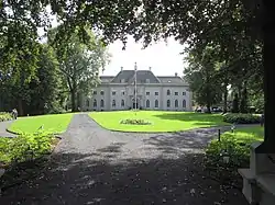 Huis Landfort | |||
| |||
.svg.png.webp) 在海爾德蘭省的位置 | |||
| 坐标:51°53′N 6°23′E | |||
| 國家 | 荷蘭 | ||
| 省份 | 海爾德蘭省 | ||
| 設立 | 2005年1月1日[1] | ||
| 政府[2] | |||
| • 行政机构 | Municipal council | ||
| • Mayor | Otwin van Dijk (PvdA) | ||
| 面积[3] | |||
| • 总计 | 137.95 平方公里(53.26 平方英里) | ||
| • 陸地 | 136.15 平方公里(52.57 平方英里) | ||
| • 水域 | 1.80 平方公里(0.69 平方英里) | ||
| 海拔[4] | 15 公尺(49 英尺) | ||
| 人口(1月 2019)[5] | |||
| • 總計 | 39,473人 | ||
| • 密度 | 290人/平方公里(800人/平方英里) | ||
| 时区 | CET(UTC+1) | ||
| • 夏时制 | CEST(UTC+2) | ||
| Postcode | 7050–7084 | ||
| Area code | 0315 | ||
| 網站 | www | ||


參考資料
- [Municipal divisions on 1 January 2005]. cbs.nl. CBS. [15 July 2014]. (原始内容存档于2015-09-29) (荷兰语).
- [Members of the board]. Gemeente Oude IJsselstreek. [15 July 2014]. (原始内容存档于2014年7月28日) (荷兰语).
- [地区关键统计数字]. 荷蘭中央統計局统计数据. 荷蘭中央統計局. 2013-07-02 [2014-03-12] (荷兰语).
- . Actueel Hoogtebestand Nederland. Het Waterschapshuis. [15 July 2014]. (原始内容存档于2018-12-26) (荷兰语).
- [Population growth; regions per month]. 荷蘭中央統計局统计数据. 荷蘭中央統計局. 1 January 2019 [2019年1月1日] (荷兰语).
外部連結
 维基共享资源上的相關多媒體資源:旧艾瑟尔斯特雷克
- Official website (页面存档备份,存于)
This article is issued from Wikipedia. The text is licensed under Creative Commons - Attribution - Sharealike. Additional terms may apply for the media files.