聖安德魯區 (巴巴多斯)
聖安德魯區位於巴貝多北部,與聖盧西、聖彼得區、聖詹姆斯區、聖托馬斯區、聖約瑟夫區等區相鄰。
- iso:code:3166:BB, International Organization for Standardization
| Saint Andrew | |
|---|---|
| Parish | |
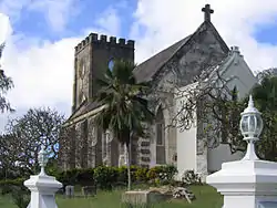 Saint Andrew´s Parish Church | |
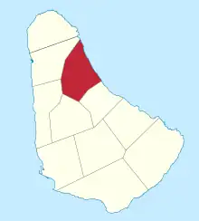 Map of Barbados showing Saint Andrew | |
| 坐标:13°14′N 59°34′W | |
| Country | Barbados |
| Largest village | Belleplaine |
| 政府 | |
| • 类型 | Parliamentary democracy |
| • Parliamentary seats | 1 |
| 面积 | |
| • 总计 | 36 平方公里(14 平方英里) |
| 人口(2010 census) | |
| • 總計 | 5,139人 |
| • 密度 | 143人/平方公里(370人/平方英里) |
| ISO 3166码 | BB-02[1] |
This article is issued from Wikipedia. The text is licensed under Creative Commons - Attribution - Sharealike. Additional terms may apply for the media files.