艾瑟尔河畔卡佩勒
艾瑟尔河畔卡佩勒(荷蘭語:,[kaːˈpɛlə ʔaːn dɛn ˈɛisəl] (ⓘ))是荷兰南荷兰省的一个市镇。该市镇2005年人口65,605,面积15.42 km²,其中1.13 km²为水域。它坐落于鹿特丹的东边,在荷兰艾瑟尔河(Hollandse IJssel)上。
| 艾瑟尔河畔卡佩勒 Capelle aan den IJssel | |||
|---|---|---|---|
| 市镇 | |||
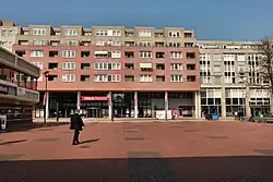 城市广场 | |||
| |||
.svg.png.webp) 艾瑟尔河畔卡佩勒在南荷兰省的位置 | |||
| 坐标:51°56′N 4°35′E | |||
| 国家 |  荷蘭 荷蘭 | ||
| 省份 | 南荷兰省 | ||
| 政府[1] | |||
| • 行政机构 | 市议会 | ||
| • 市长 | Peter Oskam (CDA) | ||
| 面积[2] | |||
| • 总计 | 15.40 平方公里(5.95 平方英里) | ||
| • 陸地 | 14.14 平方公里(5.46 平方英里) | ||
| • 水域 | 1.26 平方公里(0.49 平方英里) | ||
| 海拔[3] | −2 公尺(−7 英尺) | ||
| 人口(1月 2019)[4] | |||
| • 總計 | 66,818人 | ||
| • 密度 | 4,725人/平方公里(12,240人/平方英里) | ||
| 居民称谓 | Capellenaar | ||
| 时区 | CET(UTC+1) | ||
| • 夏时制 | CEST(UTC+2) | ||
| 邮政编码 | 2900–2909 | ||
| 电话区号 | 010 | ||
| 網站 | www | ||


參考資料
- [Mayor]. Bestuur en Organisatie. Gemeente Capelle aan den IJssel. [16 July 2013]. (原始内容存档于20 November 2013) (荷兰语).
- [地区关键统计数字]. 荷蘭中央統計局统计数据. 荷蘭中央統計局. 2013-07-02 [2014-03-12] (荷兰语).
- . Actueel Hoogtebestand Nederland. Het Waterschapshuis. [16 July 2013]. (原始内容存档于2013-09-21) (荷兰语).
- [Population growth; regions per month]. 荷蘭中央統計局统计数据. 荷蘭中央統計局. 1 January 2019 [2019年1月1日] (荷兰语).
外部链接
- Official website (页面存档备份,存于)
- Capelleaandenijssel.com (页面存档备份,存于)
- Map
- Capelle local radio & tv (页面存档备份,存于)
This article is issued from Wikipedia. The text is licensed under Creative Commons - Attribution - Sharealike. Additional terms may apply for the media files.